

Residents across Tri-State area and Sequatchie Valley should prepare for the possibility of strong winds, heavy rainfall, and localized flooding this weekend as Hurricane Isaias approaches the northern Gulf Coast.
The storm is expected to make landfall somewhere along the Gulf Coast late Friday night or early Saturday morning before moving inland. While Isaias is expected to weaken as it moves northward with the center tracking a bit to our west over Middle Tennessee; however, its remnants could still bring significant weather impacts to the Tennessee Valley throughout Saturday and into Sunday.
According to the National Weather Service, the greatest concerns for our area will be gusty winds, periods of heavy rainfall, and the possibility of downed trees and scattered power outages.

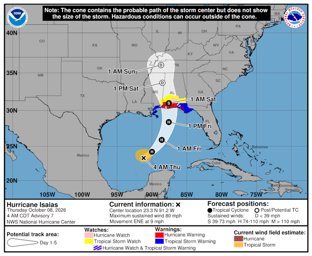
Image Credit: NWS
Communities across Marion, Sequatchie, Bledsoe, Hamilton, and surrounding counties in Southeast Tennessee could experience deteriorating weather conditions during the day Saturday. Similar impacts are possible across Northeast Alabama and Northwest Georgia, including the Chattanooga metropolitan area.
Forecasters say strong wind gusts could become particularly troublesome in mountainous areas and along the Cumberland Plateau. Saturated ground, combined with gusty winds, could increase the possibility of trees falling across roadways or onto power lines.
Heavy rainfall is another concern, particularly in low-lying areas, along creeks and streams, and in locations that are prone to flooding. While widespread flooding is not a certainty, periods of intense rainfall could produce localized flash flooding and hazardous driving conditions.
Across Northwest Georgia, forecasters are also monitoring the possibility of isolated tornadoes associated with the tropical system. The extent of that threat will depend on the storm’s eventual track and how its circulation develops as it moves inland.
The National Hurricane Center continues to monitor Isaias as it approaches the Gulf Coast. The storm’s exact path, forward speed, and intensity at landfall remain important factors in determining how much wind and rain reach our area.
Residents are encouraged to secure loose outdoor items, charge electronic devices, and make preparations for possible power interruptions ahead of the weekend. Those planning to attend outdoor events, high school football games, or other activities Saturday should pay close attention to changing weather conditions and possible schedule adjustments.
Although our local area is well inland from the Gulf Coast, tropical systems can still produce damaging winds and flooding hundreds of miles from where they make landfall.
Forecast details are likely to change as Isaias approaches the coast, and additional watches or advisories could be issued for portions of the Tennessee Valley.
Residents should continue monitoring forecasts and official updates from the National Weather Service and local emergency management agencies.
SValleyNow.com will continue to follow Hurricane Isaias and provide updates on potential impacts across the Tennessee Valley as the weekend approaches.